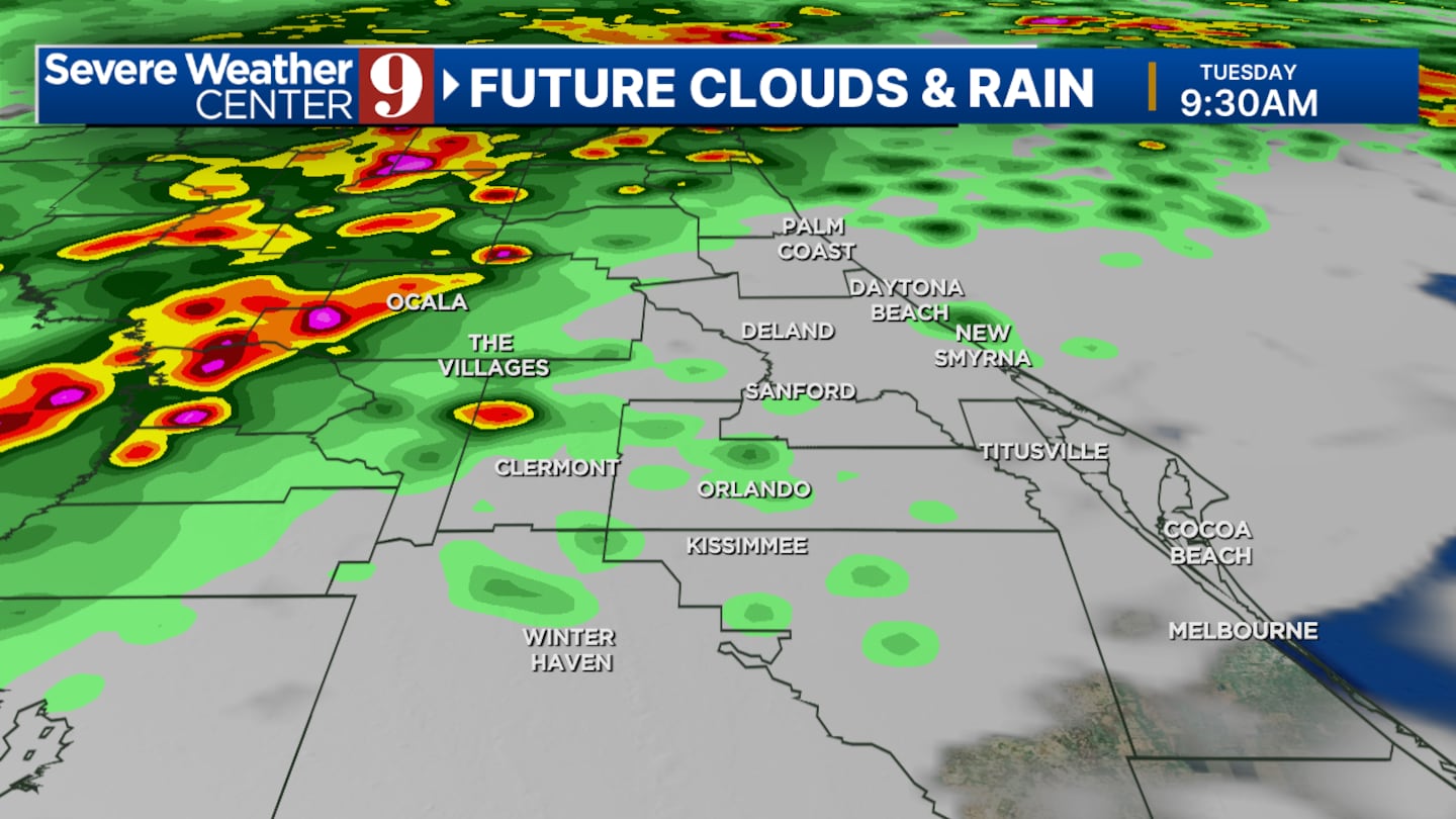
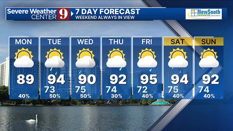
Another round of storms will move through the area late Monday night.
Keep your umbrella close for more rain and possible storms Tuesday morning
Another round of late night storms Monday, more storms possible Tuesday morning Another round of late night storms Monday, more storms possible Tuesday morning
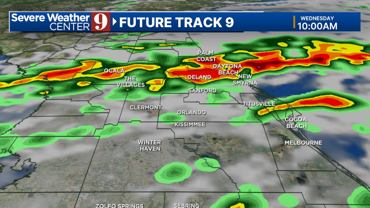
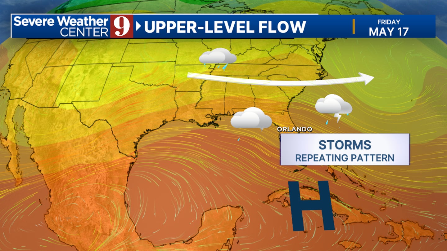
Expect scattered storms to continuie through mid-week.
Original Story:
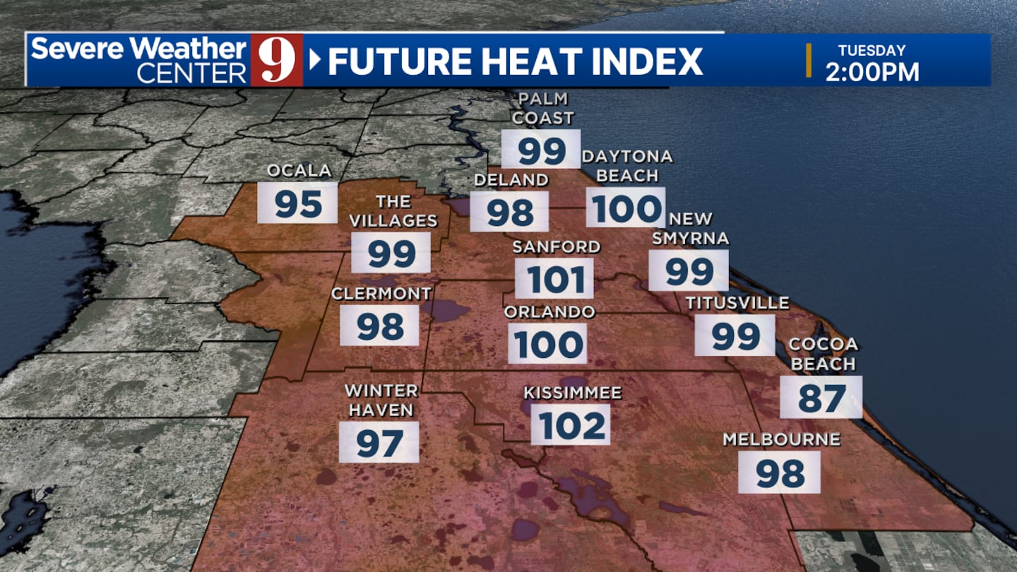
Have any outdoor projects over the next few days? Be sure to monitor the forecast as there are multiple chances for rain this week.
On Monday, several spotty storms could develop mid-afternoon, tapering off by the early evening -- especially in inland areas away from the beaches, certified meteorologist George Waldenberger said.
“Lightning and areas of heavy rain are the main threats, with an outside chance of pockets of wind damage,” he said. “We’ll monitor the storms each day on Channel 9.”
Watch Channel 9 Eyewitness News to be updated on any changes to the forecast.
Click here to download our free news, weather and smart TV apps. And click here to stream Channel 9 Eyewitness News live.
0 of 15
Tallahassee storm damage Citizens are reporting damage across Tallahassee. (City of Tallahassee)
Tallahassee storm damage Citizens are reporting damage across Tallahassee. (City of Tallahassee)
Tallahassee storm damage Citizens are reporting damage across Tallahassee. (City of Tallahassee)
Tallahassee storm damage Citizens are reporting damage across Tallahassee. (City of Tallahassee)
Downed tree Downed tree at Old Bainbridge and Setting Sun Boulevard. (Leon County Sheriff's Office )
Storm damage Crews are hard at work clearing downed trees and power lines. (Tallahassee Police Department)
Downed tree Downed tree at Old Bainbridge and Setting Sun Boulevard. (Leon County Sheriff's Office )
Tallahassee With possible tornadic activity in Tallahassee, early assessments of the electric grid show severe damage to transmission lines, impacting 11 substations. Restoration will possibly take through the weekend. Crews from eight utilities are on their way to assist from Central Florida, Louisiana, Alabama and Jacksonville. Over 66,000 customers are without service. (City of Tallahassee)
Fallen trees Fallen trees and limbs reported in the Timberlake neighborhood off Apalachee Parkway. (City of Tallahassee)
Fallen trees Fallen trees and limbs reported in the Timberlake neighborhood off Apalachee Parkway. (City of Tallahassee)
Storm damage Crews are hard at work clearing downed trees and power lines. (Tallahassee Police Department)
Fallen trees Fallen trees and limbs reported in the Timberlake neighborhood off Apalachee Parkway. (City of Tallahassee)
Fallen trees Fallen trees and limbs reported in the Timberlake neighborhood off Apalachee Parkway. (City of Tallahassee)
Afternoon forecast: Monday, May 13
0 of 13
Views of the Northern Lights in North America MANNING PARK, BRITISH COLUMBIA - MAY 11: A couple watch the aurora borealis, commonly known as the northern lights on May 11, 2024 in Manning Park, British Columbia, Canada. (Photo by Andrew Chin/Getty Images) (Andrew Chin/Getty Images)
Views of the Northern Lights in North America LATOURELL, OREGON - MAY 11: The Northern Lights are seen above the Columbia River Gorge from Chanticleer Point Lookout in the early morning hours of May 11, 2024 in Latourell, Oregon. Places as far south as Alabama and parts of Northern California were expected to see the aurora borealis, also known as the northern lights from a powerful geomagnetic storm that reached Earth. (Photo by Mathieu Lewis-Rolland/Getty Images) (Mathieu Lewis-Rolland/Getty Images)
Views of the Northern Lights in North America LATOURELL, OREGON - MAY 11: Kathryn Richer (left) and her friend Andrea gaze upon the Northern Lights at Chanticleer Point Lookout on the Columbia River Gorge in the early morning hours of May 11, 2024 in Latourell, Oregon. Places as far south as Alabama and parts of Northern California were expected to see the aurora borealis, also known as the northern lights from a powerful geomagnetic storm that reached Earth. (Photo by Mathieu Lewis-Rolland/Getty Images) (Mathieu Lewis-Rolland/Getty Images)
Views of the Northern Lights in North America MANNING PARK, BRITISH COLUMBIA - MAY 11: The Aurora borealis, commonly known as the northern lights, is seen on May 11, 2024 in Manning Park, British Columbia, Canada. (Photo by Andrew Chin/Getty Images) (Andrew Chin/Getty Images)
Views of the Northern Lights in North America MANNING PARK, BRITISH COLUMBIA - MAY 11: Aurora borealis, commonly known as the northern lights is seen on May 11, 2024 in Manning Park, British Columbia, Canada. (Photo by Andrew Chin/Getty Images) (Andrew Chin/Getty Images)
Views of the Northern Lights in North America The Northern Lights are seen above the Columbia River Gorge from Chanticleer Point Lookout in the early morning hours of May 11, 2024 in Latourell, Oregon. Places as far south as Alabama and parts of Northern California were expected to see the aurora borealis, also known as the northern lights from a powerful geomagnetic storm that reached Earth. (Mathieu Lewis-Rolland/Getty Images)
Views of the Northern Lights in North America: Northern Lights (Aurora Borealis) illuminate the sky of San Francisco North Bay as seen from China Camp Beach in San Rafael, California. (Anadolu/Anadolu via Getty Images)
Views of Northern Lights in North America: The Northern Lights (aurora borealis) illuminate the sky of San Francisco North Bay as seen from China Camp Beach in San Rafael, California. (Anadolu/Anadolu via Getty Images)
Views of the Northern Lights in North America: The blinking lights of a plane streak through the aurora borealis, also known as the Northern Lights, which is visible over Lake Berryessa, California. (San Francisco Chronicle/Hearst N/San Francisco Chronicle via Gett)
Views of the Northern Lights in North America: An aurora lights the sky as the solar activity reached its peak and triggered geomagnetic storms on May 11, 2024 in Toronto. (China News Service/China News Service via Getty Ima)
Views of the Northern Lights in North America: The Northern Lights (aurora borealis), illuminate the sky in Rochester, New York, United States on May 11, 2024. (Anadolu/Anadolu via Getty Images)